
Modern construction projects demands precision, speed and seamless collaboration. However, one of the biggest challenges during the design and renovation is ensuring that the architects works with the accurate site information. Traditional survey drawings often leaves room for interpretation hence leading to the design revisions, coordination issues and construction delays.
BIM has transformed this workflow by creating a shared digital environment where the surveyors and architects collaborates using the same source of truth. Instead of relying solely on the 2D drawings, teams can work with intelligent 3D models that accurately represents the existing site conditions.
This collaborative approach minimizes the design errors, accelerates project delivery and enables better decision-making throughout the project lifecycle.
Why Collaboration Between Architects and Surveyors Matters?
Surveyors are responsible for capturing precise measurements of existing buildings, terrain and infrastructure. Architects use this information to develop design concepts, prepare construction documentation and coordinate with the engineering disciplines.
When these two teams works independently using the disconnected datasets, projects often face:
- Design conflicts caused by inaccurate measurements
- Time-consuming site revisits
- Misaligned structural and architectural elements
- Unexpected construction variations
- Increased project costs due to redesign
BIM bridges this gap by enabling both professionals to access and update a coordinated digital model throughout the project.
According to the research by Dodge Construction Network, projects using BIM-based collaboration reports improved coordination, reduced reworks and better project predictability compared to the traditional documentation workflows.
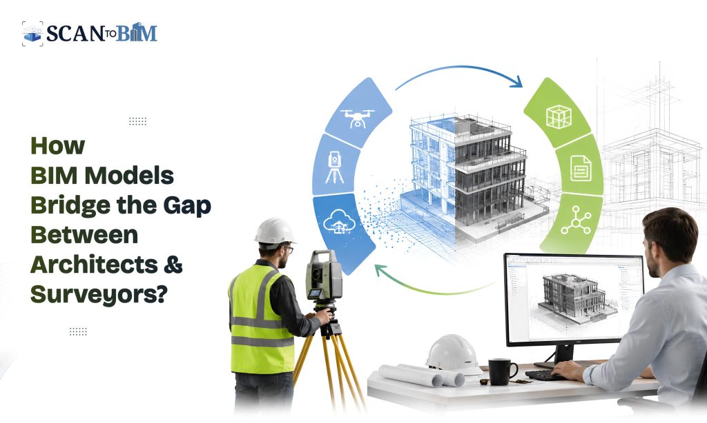
The BIM-Based Collaboration Workflow
- Site Reality Capture
The collaboration begins with capturing accurate site conditions using technologies such as:
- Terrestrial laser scanners
- Mobile laser scanning
- UAV photogrammetry
- Total stations
- GPS surveying
Millions of measurements are collected to generate a highly detailed point cloud representing the existing environment.
Unlike the manual surveys that records the selected measurements, laser scanning captures virtually every visible surface, significantly improving documentation completeness.
- Creating the Digital Foundation
The captured point cloud is processed and converted into usable design information.
Depending on the project’s requirements, organizations may begin with Scan to CAD Services to generate accurate 2D floor plans, elevations, sections and site layouts. These drawings provides a reliable base for design verification, permitting and renovation planning.
For projects requiring intelligent digital models, the point cloud is transformed through Scan to BIM, thus producing a data-rich model containing architectural, structural and MEP elements with varying Levels of Development (LOD).
This model becomes the central reference for every stakeholder involved in the project.
- Architects Develop Design Concepts
Once the BIM model is available, architects can begin designing with confidence because they are working from the verified site conditions rather than just the estimated dimensions.
The BIM model allows architects to:
- Validate existing building geometry
- Identify spatial constraints
- Plan renovations accurately
- Develop extension concepts
- Evaluate circulation and accessibility
- Generate construction documentation
Because the model accurately reflects the reality, architects spend less time correcting the dimensional errors later in the design process.
- Surveyors Validate Design Accuracy
Surveyors continues to support the project throughout the design development.
Their responsibilities includes:
- Verifying proposed layouts
- Confirming critical dimensions
- Comparing design against existing conditions
- Updating models after additional site surveys
- Supporting construction staking and verification
Since BIM models can be continuously updated, architects always have access to the latest site information.
- Real-Time Coordination
One of BIM’s greatest strengths is enabling the multidisciplinary coordination.
Architects, surveyors, structural engineers and MEP consultants all refer to the same model rather than just maintaining separate drawing sets.
This shared environment allows teams to:
- Detect inconsistencies early
- Reduce duplicated work
- Track design revisions
- Coordinate design changes
- Maintain the data consistency across disciplines
Cloud-based collaboration platforms further improves the communication by enabling multiple stakeholders to review models simultaneously from different locations.
How BIM Improves Collaboration?
Single Source of Truth
Instead of exchanging multiple CAD files and revised drawings, every stakeholder works from one coordinated model.
This reduces the confusion and ensures that everyone references the latest project information.
Better Design Accuracy
Accurate survey information directly improves the architectural design quality.
Design decisions are based on verified dimensions instead of assumptions, thus reducing the construction risks.
Studies published by the National Institute of Building Sciences indicates that inadequate interoperability and inaccurate information can contribute to the significant project inefficiencies, highlighting the importance of reliable digital collaboration.
Faster Decision-Making
Architects can quickly evaluate the design alternatives because the existing conditions are already digitally available.
Surveyors can immediately verify the proposed changes without recreating the drawings from scratch.
This significantly shortens the design cycles.
Reduced Reworks
Construction reworks remains one of the industry’s largest cost drivers.
Research from the Construction Industry Institute estimates that rework can account for approximately 5–15% of total construction costs, much of it resulting from coordination and documentation issues.
Using coordinated BIM models helps identify problems before construction begins, reducing costly revisions.
Improved Renovation Projects
Renovation projects particularly benefits from the BIM collaboration because the existing buildings often differs from their original drawings.
Laser-scanned BIM models allows the architects to design around the actual building conditions rather than just outdated documentation, thus reducing surprises during construction.
Information Flow Between Surveyors and Architects
A typical BIM collaboration follows this sequence:
- Surveyors captures the existing site conditions.
- Point cloud data is registered post processing.
- BIM specialists develops an intelligent model.
- Architects use the model for the design development.
- Surveyors validates the dimensions and site constraints.
- Engineers coordinates the structural and MEP systems.
- Construction teams executes using the coordinated models.
- Updated surveys can be incorporated into the BIM model whenever changes occurs.
This continuous information exchange improves accuracy at every project stage.
Technologies Supporting BIM Collaboration
Several technologies strengthens the collaboration between the architects and surveyors:
- Terrestrial LiDAR scanning
- UAV photogrammetry
- GNSS surveying
- Autodesk Revit
- Autodesk ReCap Pro
- Navisworks
- BIM 360 and Autodesk Construction Cloud
- Common Data Environments (CDE)
These platforms enables efficient data sharing, model coordination and version control across the project teams.
Best Practices for Successful Collaboration
Organizations that maximizes the BIM collaboration typically follow these practices:
- Establish a BEP early.
- Define LOD for project deliverables.
- Use standardized naming conventions and file structures.
- Maintain a centralized Common Data Environment.
- Schedule regular coordination and model review meetings.
- Validate survey accuracy before the design begins.
- Update BIM models whenever new site information becomes available.
Following these practices ensures that the architects always design using the most current and reliable project data.
Future of Architect–Surveyor Collaboration
Emerging technologies are making BIM collaboration even more powerful.
Artificial intelligence is beginning to automate feature recognition from the point clouds, accelerating the model creation. Digital twins enables the continuous updates throughout a building’s operational lifecycle, while cloud-based collaboration platforms allows the global project teams to work together in real time.
As automation, AI and reality capture technologies continues to mature, architects and surveyors will spend less time managing the data and more time delivering innovative, high-quality designs.
Conclusion
Successful projects begins with accurate information and effective collaboration. BIM provides the shared digital environment that connects the surveyors’ precise site data with the architects’ design expertise, ensuring that every decision is based on reliable information rather than just the assumptions.
By integrating reality capture, intelligent modeling and coordinated workflows, organizations can reduce errors, improve communication, accelerate the project delivery and produce more accurate construction documentation.
As the AEC industry continues its digital transformation, collaborative BIM workflows are becoming an essential foundation for efficient, high-quality project execution.