Introduction
As-built data accuracy is the backbone of reliable BIM workflows. However, relying on a single data capture method often results in gaps—either in precision, coverage or visual context. This is where the integration of UAVs (Unmanned Aerial Vehicles), LiDAR and photogrammetry becomes a game-changer.
By combining these technologies, AEC professionals can generate highly accurate, data-rich models that significantly improves the downstream BIM processes. From large infrastructure projects to complex retrofit environments, integrated reality capture is redefining how the digital twins are created and utilized.
Understanding the Technologies
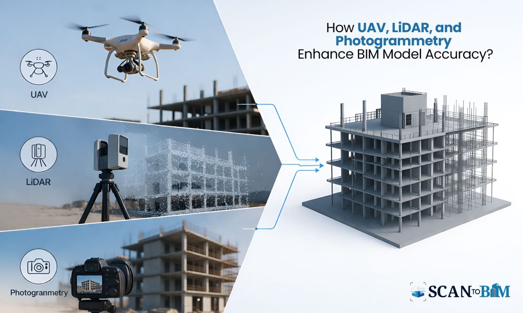
- UAV (Drone-Based Data Capture)
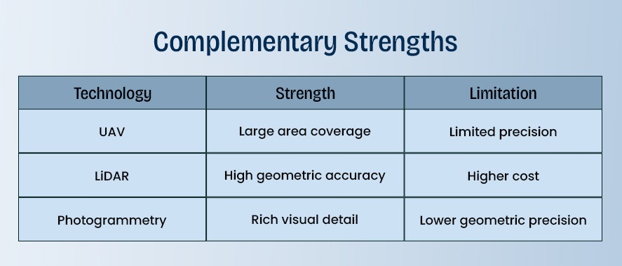
UAVs enables the rapid data acquisition over the large and hard-to-access areas. Equipped with cameras and LiDAR sensors, the drones can capture aerial perspectives that are otherwise difficult to obtain.
Key Advantages:
- Fast coverage of large sites (up to 100+ acres/day depending on terrain)
- Reduced need for manual surveying
- Improved safety in hazardous environments
- LiDAR (Light Detection and Ranging)
LiDAR uses laser pulses to measure the distances and generate highly accurate 3D point clouds.
Key Advantages:
- Accuracy up to ±2–5 mm in controlled environments
- Ability to capture the geometry in low-light or textureless surfaces
- Penetration through vegetation (useful in terrain mapping)
- Photogrammetry
Photogrammetry converts 2D images into 3D models using overlapping photographs and advanced algorithms.
Key Advantages:
- High-resolution visual textures
- Cost-effective compared to LiDAR
- Ideal for façade modeling and heritage documentation
Why Integration Matters in BIM Workflows?
Individually, each technology has limitations. When combined, they create a comprehensive dataset that enhances the BIM output quality.
Integrated Approach Benefits:
- UAV + LiDAR → Accurate topography + fast data capture
- LiDAR + Photogrammetry → Precise geometry + realistic textures
- UAV + Photogrammetry → Efficient aerial modeling
Workflow: From Capture to BIM
Step 1: Data Acquisition
- UAVs captures the aerial imagery and LiDAR scans
- Ground-based LiDAR scans captures the interiors and detailed geometry
- Photogrammetry captures the high-resolution imagery
Step 2: Point Cloud Generation
- LiDAR produces the dense point clouds
- Photogrammetry fills the gaps and enhances the visual context
- Data is merged into a unified coordinate system
Step 3: Data Registration & Cleaning
- Alignment of multiple scans
- Noise reduction and filtering
- Accuracy validation using control points
Step 4: BIM Modeling
- Conversion of point clouds into parametric BIM models
- Extraction of architectural, structural and MEP elements
- LOD development based on the project requirements
Key Benefits for BIM Output
- Higher Accuracy & Reliability
Integrated datasets reduces the errors significantly. Studies indicates that hybrid capture methods can improve the modeling accuracy by up to 30–40% compared to single-source data.
- Reduced Rework
Clash detection and coordination become more effective when the models are based on the precise as-built conditions thus minimizing the sRFIs and site changes.
- Faster Project Turnaround
Parallel data capture and processing reduce the timelines by up to 25%, especially in the large-scale projects.
- Enhanced Visualization
Photogrammetry adds realistic textures thus improving the stakeholder communication and design validation.
Use Cases Across AEC
Infrastructure Projects
- Highways, rail corridors and bridges benefits from the UAV + LiDAR integration for terrain and structural mapping.
Retrofit & Renovation
- Accurate as-built models reduces the uncertainty in existing structures.
Industrial Facilities
- Complex MEP systems requires high-precision LiDAR combined with visual clarity from photogrammetry.
Heritage Conservation
- Photogrammetry ensures the detailed texture mapping, while the LiDAR captures the structural integrity.
Challenges & Best Practices
Challenges
- Large data volumes requiring the robust processing infrastructure
- Data alignment complexities
- Skill requirements for handling multiple technologies
Best Practices
- Define LOD requirements before the data capture
- Use ground control points (GCPs) for accuracy
- Integrate the datasets using advanced software platforms
- Collaborate with experienced service providers
Role of Advanced Conversion Services
To fully leverage the integrated reality capture, organizations often rely on the specialized Scan to BIM Conversion Services. These services ensure that the raw data from UAV, LiDAR and photogrammetry is transformed into the structured, intelligent BIM models.
Additionally, Point Cloud Modeling Services plays a critical role in converting the dense point cloud datasets into usable architectural and engineering elements thereby enabling the seamless coordination across disciplines.
Conclusion
The convergence of UAV, LiDAR and photogrammetry is not just a technological advancement—it is a strategic shift in how BIM models are created and validated. By leveraging the strengths of each method, the AEC professionals can achieve unparalleled accuracy, efficiency and visualizations in their projects.
As the projects become more complex and data-driven, adopting an integrated reality capture approach will be essential for delivering high-quality BIM outputs and maintaining a competitive edge in the industry.