Introduction
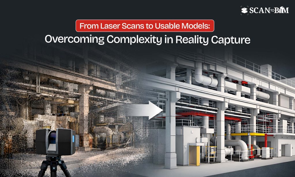
Reality capture has transformed how existing conditions are documented across the AEC industry. Using laser scanning, photogrammetry and drone-based surveys, project teams can collect millions of data points to create highly accurate digital representations of the real-world environments. However, when it comes to the complex sites—such as industrial facilities, heritage structures, dense urban environments and infrastructure corridors—the process becomes significantly more demanding.
Studies indicates that reality capture can improve the measurement accuracy by up to ±2–6 mm and reduce the reworks by 20–30%, but only when executed with the right planning and workflows. Without proper strategies, complex site conditions can lead to incomplete data, misaligned scans as well as the costly downstream errors.
Key Challenges in Reality Capture for Complex Sites
- Limited Accessibility and Obstructions
Complex sites often include restricted zones, congested layouts or hazardous environments. Mechanical rooms, plant facilities or active construction zones can obstruct the scanner placement and line-of-sight visibility.
Impact:
- Data gaps in critical areas
- Increased need for re-scanning
- Safety risks during data collection
- Line-of-Sight Limitations in Laser Scanning
Terrestrial laser scanners rely heavily on the direct visibility. In dense environments with overlapping systems (MEP, structural, equipment), capturing every element becomes difficult.
Impact:
- Shadowing and occlusions
- Missing geometry in the congested zones
- Reduced model reliability
- Data Volume and Processing Complexity
A single large-scale project can generate hundreds of gigabytes to terabytes of point cloud data. Managing, processing and converting this data into usable models demands robust infrastructure and specialized expertise.
Impact:
- Longer processing times
- High computational costs
- Increased risk of data mismanagement
- Alignment and Registration Errors
Inaccurate scan alignment can cause deviations in the final model. Even small registration errors can create significant discrepancies when integrated into the BIM workflows.
Impact:
- Dimensional inaccuracies
- Coordination issues during the design and construction
- Increased reworks during the modeling
- Environmental and Lighting Conditions
Outdoor and semi-enclosed sites are affected by weather, lighting and reflective surfaces. Glass, water and metallic finishes can distort the scan data.
Impact:
- Noise in point cloud data
- Reduced scan accuracy
- Additional cleanup requirements
- Integration with BIM and CAD Workflows
Transforming raw scan data into structured models is not always straightforward. Converting point clouds into intelligent BIM elements requires interpretation, modeling standards and domain expertise.
Impact:
- Inconsistent modeling outputs
- Delays in project timelines
- Misalignment with project deliverables
Best Practices for Accurate Reality Capture in Complex Sites
- Pre-Scan Planning and Site Assessment
A detailed site assessment is critical before the scanning begins. This includes identifying access points, defining scan positions and evaluating the potential obstructions.
Best Practice:
- Develop a structured scan plan with the optimal scanner placement
- Use simulation tools to predict the coverage gaps
- Coordinate with the site teams for access and safety
- Use of Hybrid Capture Technologies
Relying on a single capture method is often insufficient for complex sites. Combining terrestrial laser scanning with the drones and handheld devices improves coverage.
Best Practice:
- Use drones for rooftops and inaccessible areas
- Deploys handheld scanners for tight or confined spaces
- Integrate photogrammetry for enhanced texture mapping
- High-Density Scanning in Critical Zones
Not all areas require similar level of detail. Prioritizing high-density scans in the critical zones ensures accuracy where it matters most.
Best Practice:
- Increase scan resolution for MEP-heavy or structural zones
- Use lower density for non-critical areas to optimize the file size
- Robust Data Registration and Quality Checks
Accurate alignment of scans is essential for reliable outputs. Implementing control points and validation checks minimizes the errors.
Best Practice:
- Use ground control points (GCPs) for improved accuracy
- Perform iterative registration checks
- Validate point cloud accuracy against the known dimensions
- Efficient Data Management and Segmentation
Handling large datasets requires the structured workflows to avoid bottlenecks.
Best Practice:
- Segment point clouds by zones or disciplines
- Use cloud-based platforms for collaboration
- Implement standardized naming and file management protocols
- Skilled Conversion to BIM and CAD Models
The value of reality capture lies in its usability. Converting point cloud data into actionable models requires expertise in modeling standards and project requirements.
Best Practice:
- Aligns modeling with LOD (Level of Development) requirements
- Ensures consistency in the object classification and metadata
- Leverage experienced teams offering Scan to BIM Services and Scan to CAD Services for precise model generation
Industry Insights and Trends
- The global reality capture market is projected to grow at a CAGR of over 12–15%, driven by increasing adoption in infrastructure and renovation projects.
- Over 70% of rework in retrofit projects is attributed to inaccurate existing condition data—highlighting the importance of precise scanning workflows.
- Integration with AI and automation is improving point cloud processing efficiency by up to 40%, reducing manual intervention.
Conclusion
Reality capture plays a critical role in enabling data-driven decision-making across complex construction environments. However, its success depends on how well the challenges such as accessibility, data management and integration are addressed.
By adopting the structured planning, leveraging the hybrid technologies and ensuring the accurate data processing, project teams can significantly enhance the reliability of captured data.
As projects become more complex and demand higher precision, reality capture—supported by the optimized workflows and expert-driven Scan to BIM Services and Scan to CAD Services—will continue to play a critical role in bridging the gap between the existing conditions and digital execution.